
The links to the respective websites
for concepts Ia to IX can be found here:
(Each page has its own table of contents)

Thema IX Guideline for foot and cycle path markings
Contents of this page:
- Basis and legal basis for all road users §1 StVO
- Description of the effects of current conditions on walking and cycling
- Markings should be standardised, safe and comprehensible - for all roads, for all people
- Why a guideline?
- Guideline for foot and cycle path markings (download)
- Slides from the guideline for foot and cycle path markings
- Legal basis
-
Goal
- Further solutions and improvements
JM 20.04.2026
1. Basis and legal basis for all road users §1 StVO
Road Traffic Regulations (StVO)
§ 1 Basic rules
(1) Participation in road traffic requires constant caution and mutual consideration.
(2) Anyone taking part in traffic must behave in such a way that no one else is harmed, endangered or hindered or inconvenienced more than is unavoidable under the circumstances.
2. Description of the effects of current conditions on walking and cycling
We still have a lot of fatal accidents in Germany.
(In 2024: 2,780 road deaths, 50,300 serious injuries and 363,000 injuries)
We have many rules:
- the Road Traffic Act,
- the administrative regulations to the StVO,
- many court judgements and
- the FGSV (Research Association for Roads and Traffic) with the guidelines, ERA, EFA, RAST06, RAL etc.
Everything is mainly geared towards the ease of motorised traffic.
The best thing would be
we could provide 2.50 metre wide footpaths and 2.50 metre wide cycle paths on both sides of the roads.
But there must also be space for emergency vehicles, public transport and refuse collection vehicles.
3. Markings should be standardised, safe and comprehensible - for all roads, for all people
Our cities and municipalities are characterised by a patchwork of footpaths and cycle paths. There is often a lack of continuous, safe and clearly marked paths for non-motorised road users. At the same time, the number of accidents and conflicts is increasing - especially at junctions and crossroads.
This guideline for pedestrian and cycle path markings shows simple and quickly realisable solutions for making existing roads safer, clearer and fairer - without major construction work.
4. Why a guideline?
Today's transport planning is still heavily geared towards motorised private transport. Yet it is clear:
Cyclists, pedestrians, children, senior citizens and people with reduced mobility need safe routes - not as an exception, but as the standard.
Presentation of a guideline for foot and cycle path markings.
Why do we need a guideline for road markings?
- Clear, standardised markings create understanding and safety,
- All road users become more visible.
What characterises the new guideline?
- Standard solutions for intersections, junctions, roundabouts and bus stops.
- The focus is on Vision Zero, safety, accessibility and low costs.
- No restrictions or bans.
Our target groups:
Politicians and administrations, specialist planners, citizens: for rapid implementation for greater understanding and safety
Appeal:
This guideline is an open draft that will be further developed.
5. Guideline for foot and cycle path markings (download)
Content and objectives of the guideline:
Eight solutions for typical problem areas in cycling and pedestrian traffic
- Application e.g. at
-
- Intersections & roundabouts
- Junctions
- Bus stops & narrow roads
- Consideration of accessibility and safety distances
- Standardised pictogram sizes and markings
- Examples and photos from practice
New version 09 dated 8 July 2026
The road sign for junctions has been updated.
6. Slides from the guideline for foot and cycle path markings
Slides from the guideline showing some of the problems for pedestrians and cyclists that can now be solved. sufficiently wide and independent cycle paths are not listed here. However, the crossings should be checked and adapted if necessary.
Slides from the guideline showing some of the problems for pedestrians and cyclists that can now be solved. sufficiently wide and independent cycle paths are not listed here. However, the crossings should be checked and adapted if necessary.

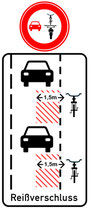
A no overtaking sign for cyclists will be erected. This new additional sign can be erected approx. 100 m before the intersection, especially before traffic lights.
The zipper, the red hatched fields and the distance of 1.50 m indicate that the distance between motor vehicles and cyclists and vice versa must be maintained even during waiting times.
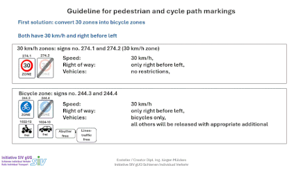
Convert 30 km/h zones into cycle zones.
A quick and cost-effective solution to make cycling more visible, without imposing restrictions
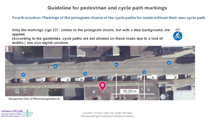
Solutions to improve the visibility of cyclists using pictogram chains.
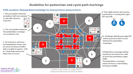
Description of a standardised solution for intersections.

Size and position of the pictograms in relation to the 1.50 m distance rules.

Cycle paths should always be on the road in the area of the stops.

Markings should also be placed inside the roundabout.
7. Legal basis
All proposed measures are based on the applicable regulations or close documented gaps - particularly in terms of Section 1 of the German Road Traffic Act (StVO) (‘mutual consideration’) and the principle of safety for all.
In principle, all legal rules must be observed, taking into account the safe driving of all road users, even if they do not have a driving licence or similar training, such as children and the elderly.
8. Goal
Markings don't have to be expensive - but they must be clear.
Standardised markings are the key to greater safety, orientation and confidence on the road - for all road users, regardless of age, language or driving skills.
9 Further solutions and improvements (in progress)
9a Acceptance and defects report for the ZOB (Central Coach Station) in Mönchengladbach
Furthermore, this is also the planned start and end point of the Krefeld–Mönchengladbach and Mönchengladbach–Roermond cycle highways.
This assessment relates exclusively to the people who use the area and should be viewed independently of the plans and contractual obligations of the parties involved.
If you find any errors, we are grateful for any advice.